Saturday, December 25, 2021

Similarities between Stanley Park and the Experimental Farm.

 Stanley Park in Vancouver, BC encompasses 1,001 acres of land, while the Farm in Ottawa is 1,012 acres. 

They are both National Historic Sites of Canada. The Farm is also:

a.) A National Interest Land Mass certified by Prime Minister Brian Mulroney in 1988;

b.) Part of a 900 square mile memorial to Canadian soldiers that was established by Prime Minister Mackenzie King in 1950. 

c.) An open area in perpetuity, recommended by Prime Minister and President of the Privy Council Louis St-Laurent; via a Privy Council Order-in-Council from March 17, 1954.

.Canadian Privy Council Orders-in-Council take legal effect when signed by the Head of State Queen Elizabeth 11; or signed by the  Governor General of Canada, who is the representive of the Head of State in this country. The Governor General of Canada in 1954 was the Right Hon.Vincent Massey. The architect Hart Massey was the son of Governor General Massey, and he designed the Sir John Carling Building, headquarters of Agriculture Canada. The Carling Building was demolished, and it was located on a hill near Queen Juliana Park, 870 Carling Avenue. Hart Massey also designed the West Annex Cafeteria, demolished by the Ottawa Civic Hospital.

The Rideau Canal, Dominion Observatory campus and Experimental Farm are all National Historic Sites of Canada. Senate Bill S-203 was created to protect the areas.

 Stanley Park is named the "Top park in the entire world." (Global News, June 18, 2014.) The CEF is "A sprawling Victorian farm that has been surrounded by a capital city is one of Canada's greatest treasures."..."Paris has L'Arc de Triomphe and the Eiffel Tower, London has Big Ben and Buckingham Palace, Washington has the Lincoln Memorial, the White House and the Smithsonian Institution and Ottawa has...a farm." (Atlas Obscura.)

They were both preserved as federal public land between 1886 and 1888.

The CEF is 'A Museum without Walls', 'An Oasis in the City', 'A national treasure to be lovingly preserved' and 'Canada's Farm'.


The above maps are from the Federal Directory of Real Property website.

1983.

Thursday, December 23, 2021

Pure evil.

The Royal B.C. Museum in Victoria, British Columbia is demolishing "Monuments to Colonialism" including life-sized dioramas of a train station, HMCS Discovery, a village, coal mine, and a salmon fishery... A curator is a collector of artifacts and a gatekeeper in museums. You so-called "curators" in Victoria have already hired wrecking crews and probably sold off the most valuable items on eBay and Kijiji.

A life-sized mockup of a Peace River, Alberta homestead at the Royal B.C. Museum..

I care about my country's history, future, landscape and culture.Ever since the Canadian National Railway was privatized in 1995, Canadians have lost hundreds of railway stations. One thousand federal lighthouses were decommissioned, and Cannery Row in Richmond, B.C. is threatened by encroaching development. 
House of Commons Ottawa February 24, 1986. Stanley Park--- Potential transfer of title from the federal government to the City of Vancouver. (Stanley Park is still a federal landmark. During the year 1988 Prime Minister Mulroney bestowed upon the park the title, National Historic Site of Canada.)
 
I am on the steps of the National Archaeological Museum in Athens, Greece in 1979. Greek residents told me that, years before, a shipping tycoon removed items from various locations in order to impress his American wife.

Tuesday, December 14, 2021

We will never lose Commissioners Park and the Observatory. Despite the fact that:

1.) The Civic has already indicated that it needs more than 50 acres of land.

2.) Sylvia Holden Park was relocated when Lansdowne was redeveloped.

Commissioners Park :"It was built from the 1920's to 1950's on the site of a former lumber yard owned by J.R. Booth. Follow the winding pathways and take in the explosion of colour in gardens filled over 250,000 tulips. In summer, the tulips are replaced by thousands of annual flowers, which create beautiful scenic views with Dows Lake in the background." (A Google description.)  A property on Fairmont Avenue is being renamed Princess Margriet Park and many tulips will be planted. 

3.) The Dominion Observatory campus was originally part of the land transaction between the Canadian government and the hospital: "The boundaries of site 11 were modified to exclude existing buildings including the Dominion Observatory, creating an irregularly shaped parcel." (NCC Federal Site Review for the new Civic Campus of the Ottawa Hospital, November 2016, page 24/256.) However, "An irregular shape would require fundamental modifications. Rating-very poor."(NCC Federal Site Review...page 45/256.)

4.) Being designated a UNESCO World Heritage Site (the Rideau Canal); Classified Federal Heritage Building; Recognized Federal Heritage Building and National Interest Land Mass apparently means nothing.

5.) The city is encouraging the creation of parkettes which encompass less than 1 acre:

 Recreational Land Strategy for Ottawa 2006-2031 - 4-4-2 Parks and Open Spaces - "The City's requirements for parks and open spaces may have to be revisited to ensure that the types of spaces required of developers reflect the need for quality space of all sorts at the right location, and at the right sizes." "Quality over quantity of space should be the guiding principle. Parks don't have to be grassy to be green. One of the many appropriate types of public green space is the plaza. Sized right and positioned at the heart of a community, it becomes a genuine focal point. The city should accept parkettes as part of the 5% parkland dedication." Commissioners encompasses 22 acres of land.

A survey:"A 1998 survey found that 74% of Ottawa-Carleton residents wanted to keep housing subdivisions off the Central Experimental Farm land, and even more (78%) did not want major office or commercial buildings there. Ottawa Mayor Jim Watson was not surprised by the results, saying that "I think the Central Experimental Farm is a real gem in the city and I don't think the public wants to take open and green space and have it developed." Results of the survey by the COMPAS research firm were reported in The Citizen on August 3, 1998."

August 3, 1998.

Wednesday, December 8, 2021

The history of Commissioners Park in Ottawa.

During the 1880's, lumber baron J.R. Booth sold property to the government of Canada for a Dominion Farm.

The Booth Barn.The photo is from Waymark.

The Holt Commission of 1915 - "Extensive parks and playgrounds were recommended including the acquirement of lands in the Laurentian Hills for a National Park, and the development of Dow's Lake and its adjacent lands as a recreational centre was strongly urged." (The Greber Report of 1950, page 199/395.)

 Dow's Lake property and nearby lands are included in the 900 square mile memorial in perpetuity to Canadian soldiers:

House of Commons Ottawa April 22, 1996 - Member of Parliament Marlene Catterall (Ottawa West-Nepean) Liberal: " Mr. Speaker, I have the pleasure to present a petition signed by close to 1,000 people...The petioners call to the attention of the House that when Jacques Greber released his plan for the national capital it was dedicated, at the direction of the cabinet, as a national war memorial to those who had fought in the wars in defence of Canada. Therefore, this petition calls on Parliament to ensure that this commitment and the dedication of the green spaces of the nations capital are maintained as a national war memorial and are not disposed of or sold.      

Members of the Dutch Royal Family visit the property.

2002 - The Man with Two Hats monument is unveiled.

 Attempts to take over the Experimental Farm. I presented this information before:

An Ottawa Journal newspaper article from February 5, 1908, page 8.

Mid 1970's - Agriculture Minister Eugene Whelan refuses to hand over 700 acres for housing.The land is north of Baseline Road from Clyde Avenue to Prince of Wales Drive. 

A February of 1988 Privy Council Order-in-Council pertaining to 91 acres:
An Order-in-Council.

1997 -"The fight for the Farm goes on", a Heritage Ottawa newsletter from Spring of 1997. Nearly 50  buildings were slated for demolition including the Dominion Observatory.

Starting in March of 2022 more than 700 mature trees will be clear cut.

Sunday, December 5, 2021

Parks belong to the people.

The citizens of Canada are losing more federal greenspaces in the Capital:

Parliament Hill - Also, private automobiles may be banned from the Parliamentary Precinct; and cars are routinely banned from the beautiful parkways that were created by Prime Minister Mackenzie King. Why? Do we not have the right to privacy, to travel without being monitored by closed-circuit cameras? De-paving the parkways is part of a long-term plan for the National Capital Region:

The scenic parkways: Sir George-Etienne Cartier; Queen Elizabeth Drive; Sir John A. Macdonald; Gatineau; Vanier; Champlain; Fortune Lake; Aviation; Colonel By Drive and the National Capital Commission Driveway on the Experimental Farm. The NCC Driveway will be impacted by the construction of a major medical centre.

Lazy Bay Commons - More than 200 trees will be clearcut so that foreign embassies can be built along Sir John A. Macdonald Boulevard. 

Mile Circle near Rockcliffe - "Confirmation of Mile Circle and Aviation Area Lands to be Preserved from Development." June 19, 2021.

Rochester Field is located next to Maplelawn on Richmond Road, Westboro. Maplelawn was designated a National Historic Site by the Historic Sites and Monuments Board of Canada.

The Lebreton Flats - As I mentioned before, federal politicians John Baird, John Manley and Barry Mather wanted to see a Lebreton Flats National Park:  House of Commons Ottawa October 22, 1969: Member of Parliament Barry Mather (New Democratic Party.) "Is the government of Canada giving favourable consideration to the establishment of a national park at the LeBreton Flats area in Ottawa?"

Russell Clayton Honey (Parliamentary Secretary to the Minister of Indian Affairs and Northern Development) Liberal: "Mr. Speaker, the answer to this question is no."

Greenbelt property - "Protect the Greenbelt from devastating development." Mer Bleue.

Commissioners at Carling Avenue and Preston Street (??) is major venue for the Tulip Festival.There is a reason why the City wants to rename 265 Fairmont Avenue, Princess Margriet Park. 

Major's Hill Park (??) - is located beside the Rideau Canal. At one time this land was part of Parliament Hill. Several acres have already been privatized.

Thursday, December 2, 2021

Canadian Parliamentary Debates.

 House of Commons Ottawa November 24, 2016. The Hon. Melanie Joly (Minister of Canadian Heritage, Liberal). "Mr. Speaker, I would like to thank the National Capital Commission for its hard work. Last spring, I asked it to do a thorough review of potential sites for the new Ottawa Civic Hospital. There was a rigorous, open and transparent process, with 8,000 people participating in it. Ultimately, the NCC came up with an excellent site which is Tunney's Pasture. I will ensure that we study this recommendation and have great discussions with the Ontario government as well. This is part of our own views of the NCC having---."

House of Commons Ottawa November 25, 2016. Mr. Randy Boissonnault (Parliamentary Secretary to the Minister of Canadian Heritage, Liberal.) "Mr. Speaker, before coming up with this recommendation, the National Capital Commission did a comparative analysis of 12 potential federal sites using 21 criteria. The Tunney's Pasture site best meets the 21 criteria, and its pre-eminance is supported by the most recent data concerning the long-range plans for urban transportation, demographics, and federal land use in the National Capital Region."

Monday, November 29, 2021

Restrictions on access to Gatineau Park. Especially for seniors, people with mobility problems and families with children.

A photo from the year 2021.
Prime Minister of Canada Mackenzie King; urban planner Jacques Greber; Parks Canada; Public Works and Government Services and many federal politicians never wanted to see Gatineau Park barricaded and subjected to draconian regulations.
Gatineau Park venues during the late 1980's and early 1990's.
Kingsmere Estate.
Kingsmere Picnic Site
Info Centre - Old Chelsea
Old Chelsea Picnic Site

Champlain Lookout
Etienne Brule Lookout
Keogan Hut
Mulvihill Lake
Dunlop Picnic Field

Penquin Picnic Field
Booth Hill  
Pink Lake (Upper Lookout)
Pink Lake (Lower Lookout)

Hickory Trail Lookout
Conference Centre - Meech
Meech L. - Blanchet Beach
L. Phillippe - Breton Beach
L. Phillippe - Campground
Black Lake

L. Lapeche Nature Centre
L. Lapeche Beaches
Lac Des Fees Amphitheatre
Luskville Falls Picnic Area

Taylor L. Semi-Wilderness
Camp Fortune Ski Area
Wakefield Grist Mill
MacLaren House-Wakefield
Brown Lake Nature Centre
 (From: "Recommendations for an Accessibility Strategy", page 15/22.)

Petition for the NCC to restore access to the Gatineau Park Parkway. 2021. This is a petition for the NCC to restore access to the Champlain Parkway, Gatineau Parkway and Fortune Lake Parkway in Gatineau Park. Starting May 1st the NCC has closed the Champlain Parkway, Gatineau Parkway and Lake Fortune Parkway for motor vehicle access except from 1pm to half an hour after sunset on Wednesday/Saturday and Sundays, which leaves access to the park by motor vehicles less than 15% of the time. Current Gatineau Park parkway schedule since May 1st, 2021. Monday, Tuesday, Thursday and Friday - closed to motor vehicles, only active use all day. Wednesday, Saturday and Sunday---Only active use until 1 pm. Motor vehicle access only from 1 pm to 30 minutes after sunset, shared with active use.

This means there is no vehicle access to the parking lots at:
Pink Lake
Waterfall Trail
Lake Mulvihill
Lake Mulvihill Picnic Area
Penguin Picnic Area
Etiane Brule Look Out
Champlain Lookout
Lake Fortune Lookout
King Mountain Picnic Area
There is no more short hikes to Pink Lake, King Mountain, Waterfall Trail, Champlain Lookout Loop or to the Western Cabin. This also limits access to any of these places on a morning ON ALL WEEK DAYS.
We see this as:
1.) Discrimination against hikers and walkers and a total bias for exclusive Gatineau Park use by cyclers for the majority of the time.
2.) Discrimination against people with disabilities, seniors, people who have physical disabilities that affect their mobility or the amount of physical activity that they are able to do.
3.) Discrimination against families with children. Access to most of the parking lots is closed.

YouTube video. "Extreme crowdedness in Gatineau Park due to the discriminatory NCC closures-Ottawa-Hull" August 17, 2021.

House of Commons Ottawa July 24, 1964.- Hon. J.P. Deschatelets (Minister of Public Works) "Mr. Speaker, yesterday the hon. member for Pontiac-Temiscaming (Mr. Martineau) asked me if it was true that the authorities of the ncc intended to interfere in the public transporation service in the National Capital." 

House of Commons Ottawa May 15, 1970. Proposal to remove motor vehicles from parkways in the National Capital Region: Mr. Gordon Duncan Blair (Grenville-Carleton) Liberal:" I would like to direct a question to the Acting Prime Minister, and I regret that I was unable to give him notice. Is the government aware of a statement or statements to the press by the Chairman of the National Capital Commission that he might close the national capital parkways in this region for a week, for the strange inquiries of...proving their importance in carrying traffic?" "The second part of my question is whether the Acting Prime Minister can assure the House that the government will not permit the people of this area this inconvenience (created) by the disruption that this extraordinary and senseless experiment will cause."

Hon. George J. McIlraith (Acting Prime Minister; Solicitor General of Canada) "The statement has caused concern. I am very doubtful that the Chairman of the National Capital Commission has any such authority under the National Capital Act passed by this Parliament."

Saturday, November 27, 2021

National Capital Commission Land Holdings.

Recommendations for an Accessibility Strategy 22 pages. Public Works Canada Guidelines, 1992. Public Works Canada, Barrier-Free Design Cost Guidelines, 1988.

 Urban Parks. - Page 14/22.

Vincent Massey Park

Hog's Back Park (as of 2006 the Hog's Back Woods are federally and privately owned.)

Commissioner's Park

Confederation Park

Jacques Cartier Park

Major's Hill Park (the City of Ottawa recently inquired about "the future" of Major's Hill Park after the NCC announced that major changes were forthcoming---regarding integration with the Chateau Laurier, the impact of a new addition on Tulip Festival and Canada Day celebrations, etc.) Current Design of the Addition and Impacts on NCC Lands "While the majority of the work will be situated within the existing Chateau Laurier Hotel property limits, there will be implications to the adjacent NCC lands and assets, which surround the proposed addition on the east, north and west sides. Permanent impacts include: 1.) Alterations to Mackenzie Avenue (Confederation Boulevard.) 2.) Alterations to Major's Hill Park, including soft and hard landscape, to provide direct pedestrian access and facilitate the link to/from the publicly-accessible main floor of the hotel (the Adam Room Corridor) and lobby. 3.) Removal of a small portion of the Upper Rideau Canal Terrace (building shell behind 1 Wellington Street) to allow for an improved link between the upper and lower terraces via the grand staircase and the new interior courtyard."

A 2008 document stated that "there should be no direct access from building (Chateau Laurier) to the park (Majors Hill Park)." (From: "Chateau Laurier Urban Design Guidance" National Capital Commission, page 11/31.)

Nepean Point Park

Rockcliffe Park

Rideau Falls Point

Linear Park

Strathcona Park

Brewery Creek Park

Victoria Island Park

Kitchissippi Point

Leamy Lake Park

Central Park/Patterson Creek

Portegeur Park

Breboeuf Park

Laurier Park

Parc des Chars de Combat

Rockcliffe Rockeries

Queen Juliana Park - (was donated to the Ottawa Hospital Corporation for a parking garage and construction zone.)

Hampton Park - (The Hampton Park Woods are now federally and city-owned as of the year 2006.)

Lebreton Flats Camping

Log Farm

Experimental Farm - (50 acres of the Farm were given to the Ottawa Hospital and nearly 600 mature trees are endangered.)

Maple Lawn Estate

Accessible Routes, Wayfinding, Site Amenities, Recreational Amenities, Special Events-Page 8/22

Accessible Routes in Federal Parks Walkways - surface, width - 1200 to 1500 mm. Recreational pathways for cyclists - 2500. For pedestrians - 1500 to 3000.

Wayfinding 

The "Central Experimental Farm" sign at Carling Avenue and Maple Drive will probably be removed because Maple Drive is being converted to an emergency vehicle route, with over 100 vehicle trips on the road every day.

Site amenities - benches and rest areas; facility entrances; washrooms and changing rooms; drinking fountains; telephones; waste receptacles; vegetation.

Recreational amenities

Special events

Recreational Pathways/Corridors

Queen Elizabeth Driveway

Colonel By Drive

Ottawa River Parkway (west).

Ottawa River Parkway (east).

Lac des Fees Parkway

Gatineau Parkway

Lac Lapeche Parkway

Westboro Beach

Remic Rapids Lookout

Des Chenes Rapids Lookout

Rideau River Pathway

Greenbelt Lands

Sarsaparilla Trail

Mer Bleue Interpretive Area

The Log Farm

Equestrian Centre

Stony Swamp (From: "Recommendations for an Accessiblity Strategy" NCC page 15/22.)

Tuesday, November 23, 2021

The Montfort Woods are protected by the designation "National Interest Land Mass."

REPORT TO THE OTTAWA PLANNING AND ENVIRONMENT COMMITTEE. Subject: Official Planning and Zoning. June 29, 2004.

Background. The site is situated behind the Montfort Hospital with a partial frontage on Lang's Road to the east. The site, known as Montfort Woods, is a natural woodlot that is surrounded by the Montfort Hospital and a long-term care facility to the south, Aviation Parkway to the west, CFB Rockcliffe to the north and the Fairhaven community to the east. The site is approximately 7 hectares (17 acres) in size. 
The National Capital Commission acquired the Montfort Woods property on January 27, 2004, and submitted Official Plan and Zoning By-law amendments.

The affected parcel of land consists of a core and marginal woodland area that includes predominantly Sugar Maple, Beech, Ash, Basswood, and Norway Maple over limestone bedrock. The applicant, the National Capital Commission (NCC) wishes to protect this woodlot for future generations.

I  included the following list on my November 11, 2020 blog entry "Protected land and waterways in the National Capital".---savecfbrockcliffe:
Airbase Lands - Federal, Private.
Arboretum Woods - Federal.
Aviation Parkway North - Federal, City.
Brittania Bay - Federal, City.
Brittania Conservation Area - Federal, City.
By-Pass Woods East - Federal.
Carlington Woods - Federal, City, Private.
Central Experimental Farm Woods - Federal.
Champlain Bridge Woods - Federal.
Champlain Bridge Islands - Federal.
Chaudiere Rapids - Federal.
Del Zotto Woods - Federal.
Deschenes Lookout - Federal.
Hampton Park Woods - Federal, City.
Hog's Back Woods - Federal, Private.
Lemieux Island - Federal, City.
Leopold Woodlot - Federal, Private.
McCarthy Woods and Southern Corridor - Federal.
Montfort Woods - Federal, Private.
Nepean Creek Corridor - Federal, Private.
NRC Woods North - Federal.
Parliament Hill - Federal.
Pinecrest Woods - Federal.
Prince of Wales Woods - Federal, City.
RA Centre Woods - Federal.
Rideau River Islands - Federal.
Rideau River Park Woods - Federal.
Riverside Park - Federal.
Rockcliffe Park East - Federal.
Rockcliffe Park West - Federal.
Rockcliffe Shores - Federal  (Google: "urban natural features strategy City of Ottawa April 11, 2006.)

Monday, November 22, 2021

More questions about the Sir John Carling Site.

 House of Commons Ottawa June 21, 2017. Member of Parliament Pierre Poilievre (Carleton) Conservative: "With regard to the government's transfer of land to the Ottawa Hospital for the future site of the Civic Campus, known as the Sir John Carling Site or site #11:

(a) what is the current status of the transfer of land to the Ottawa Hospital; (b) on what date does the government anticipate the land transfer to be complete; (c) did the Ottawa Hospital incur any costs as a result of delaying the construction by a year; (d) if the answer to (c) is affirmative, what are the costs, and will the government reimburse the Ottawa Hospital; (e) how many trees are there at site No. 11; (f) what buildings are currently located at site No. 11, broken down by (i) names and address (ii) purpose and current use (iii) whether the buildings will be demolished or moved to another location; (g) what will be the total cost of preparing the site for the Civic Campus to be built; (h) what will be the additional costs specific to building the Civic campus at site No. 11, including (i) the cost of building on a sloped surface; (ii) the cost of being located near a fault line; (iii) the cost of removing or transplanting the trees referred to in (e);

(iv) any other costs due to site No. 11's unique features; (i) which organization or level of government will pay for the land preparation and additional costs noted in (g) and (h); (j) does the government have any estimates on the cost of preparing site No. 11 for a large institutional occupant, and, if so, what are the details; (k) what is the market value for the land at site No. 11; (l) what will be the rental rate or sale price of site No. 11 to the Ottawa Hospital; (m) which organization or level of government will pay for the at least $11.1 million in contamination remediation, as estimated by Public Services and Procurement Canada; (n) is there any other contamination that needs to be remedied that is not captured in the $11.1 million figure; more...

Sunday, November 21, 2021

"Concerned about ballooning costs, Poilievre wants hospital site revisited."

 An Ottawa Citizen article by Elizabeth Payne, March 29, 2017. Comments in the article by Member of Parliament Pierre Poilievre, Conservative: "You've got a sloped surface, an irregular shape, contaminated land and you are building on a fault line. All of those things combined may lead to an extraordinary price tag and if that's true then we should know about it before we put shovels in the ground."

House of Commons Ottawa March 20, 2017. Member of Parliament Pierre Poilivere (Carleton) CPC: "With regard to the government's Ottawa Hospital Site Review, which concluded with a National Capital Commission recommendation to the Minister of Canadian Heritage on November 24, 2016":

"(a) when did the Environment Minister decide that she would order this review; (b) when did the Environment Minister ask that the Heritage Minister take over this review; (c) did the government estimate the cost of delaying the construction of the hospital by at least a year, and if so, what were the costs; (d) what was the total cost of the review as of November 24, 2016, broken down by (i) employees' salaries, (ii) contractors; (iii) consultants; (iv) land use surveys or studies ((v) other expenses; (e) what are the precise boundaries of the property to be leased to the Ottawa Hospital, known as the Sir John Carling Site or site #11 by the National Capital Commission. (g) what price does the government plan to charge as rent for the Sir John Carling Site, known as site # 11 by the National Capital Commission.(h) how much payment in lieu of taxes does the federal governmemt pay to the City of Ottawa for the Sir John Carling Site, known as site #11 by the National Capital Commission. (i) what will be the costs of preparing the site for the Ottawa Hospital to be built, and which level of government or organization will pay for them?" Question 810.

House of Commons Ottawa March 20, 2017. Member of Parliament Pierre Poilievre (Carleton)CPC: "With regard to the government's transfer of land to the Ottawa Hospital for the future of the Civic Campus, known as the Sir John Carling Site or site #11 by the National Capital Commission:

"(a) what analysis did the departments of Public Services and Procurement Canada (formerly Public Works and Government Services Canada), Agriculture and Agri-Food Canada, the National Capital Commission, and Canadian Heritage conduct at each of the 12 sites; (b) what did the National Capital Commission estimate the total land preparation costs of each of the 12 sites would be; (c) what concerns did the National Capital Commission raise regarding potential contamination of each of the 12 sites; (d) what are the boundaries of the Sir John Carling Site which will be leased to the Ottawa Hospital; (e) are the metal piles that were used for the foundation of the former Sir John Carling Building still present at the site; (f) if the answer to (e) is affirmative, what will be the cost of removing the piles; (h) if the answer to (f) is negative, what is the government's plan to accomodate the new Ottawa Hospital around the existing piles; (i) what is the estimated cost of preparing the site for the Ottawa Hospital to be built, and which level of government or organization will pay for them; (j) what contamination currently exists at the Sir John Carling Site, and how will it be mitigated or removed prior to the hospital's construction; (k) what is the estimated cost of remediating any contamination and which level of government or organization will pay for this, and (l) does the government foresee any other factors specific to the Sir John Carling Site that would increase costs or delay construction of the new hospital, and if so, what are they?" Question 811.

The land mass on the Sir John Carling Site allocated to the hospital in the year 2016:

North Boundary - Carling Avenue between Bayswater and Preston Street. East Boundary. - From Preston Street to Prince of Wales Drive. South Boundary - From Prince of Wales Drive (600 metres) to 90 degrees west to Birch Drive. West Boundary - From Birch Drive/Maple Drive up to Winding Lane and back to Carling Avene at Bayswater. (quarter of a circle around the Dominion Observatory.) (From: A Public Services and Procurement document given to MP Pierre Poilievre.)

--------------------------------------------------------------------------------------------------------------------------

On my blog entry "Do not build a hospital at Queen Juliana Park and Dow's Lake" I outlined the many reasons why the Experimental Farm is an inappropriate location for a medical centre. MP Pierre Poilievre believes that 60 acres of land directly across the street from the current Civic hospital should be annexed from the Farm. I disagree--- and the following individuals were and are opposed to the National Historic Site of Canada being encroached upon:

Prime Minister of Canada Sir Wilfrid Laurier

Prime Minister of Canada Mackenzie King

Prime Minister of Canada Louis St-Laurent

Prime Minister of Canada Pierre Trudeau

Prime Minister of Canada Brian Mulroney

Urban planner Jacques Greber - "The Experimental Farm forms a central park within a residential area of the City of Ottawa, and its avenues constitute a part of the driveways of the Federal District Commission." (The Greber Report of 1950, page 167 out of 359 pages and a photo of the Farm is included.)

Leader of the Official Opposition Walter David Baker, comments in the House of Commons November 4, 1974.

Elizabeth May, MP and Leader of the Green Party wrote a letter to Environment Minister Catherine McKenna, Google "Celebrating Earth Day Heritage Ottawa."

Member of Parliament Marlene Catterall - In a statement in the House of Commons on April 22, 1998, MP Marlene Catterall announced that the Farm was designated a National Historic Site by the Historic Sites and Monuments Board of Canada.

Minister of Public Works Erik Nielsen. Erik Nielsen and Prime Minister Brian Mulroney created the National Interest Land Mass designation in 1988, to "rein in" the National Capital Commission and prevent the City of Ottawa from using federal property as a land bank. The Experimental Farms on Carling and 1740 Woodroffe; the Greenbelt; Gatineau Park, land beside the Ottawa River, Rideau River and Rideau Canal; Lebreton Flats; land beside the scenic driveways; etc. were all designated as NILM properties.

Member of the Ontario Provincial Legislature Joel Harden.

Senator Anne Cools - a statement in the Senate of Canada, April 23, 2002: "The public fears that many other parklands, like the Experimental Farm and the Arboretum are on the National Capital Commission's list for sale.''

Ms. Maude Barlow, Honourary Chairperson of the Council of Canadians.

Minister of Public Works Howard Charles Green, PC House Leader, Secretary of State for External Affairs: A comment in the House of Commons August 1, 1958.

Minister of Public Works and Government House Leader George McIlraith.

Agriculture Minister Sydney Arthur Fisher:

Agriculture Minister Fisher and Prime Minister of Canada Sir Wilfrid Laurier on the grounds of the Experimental Farm on February 5, 1908. Archives of Canada photo.

Agriculture Minister Douglas Scott Harkness.

Agriculture Minister James Garfield Gardiner.

Agriculture Minister John Wise

Agriculture Minister Bud Olson

Agriculture Minister Eugene Whelan - During the mid-1970's the National Capital Commission wanted Agriculture Canada to sell 700 acres of the Farm for housing. The 700 acres of land were located north of Baseline Road and encompassed Clyde Avenue to Prince of Wales Drive. Minister Whelan said that "not one acre" of the property would be sold. From: A front page Ottawa Journal article.

Agriculture Minister Gerry Ritz.

Former City of Ottawa councillor Katherine Hobbs.

Former City of Ottawa councillor Clive Doucet, creator of the Internet web page called "Reimagine Ottawa."

City of Ottawa councillor Catherine McKenney.

City of Ottawa councillor Jeff Leiper.

City of Ottawa councillor Rawlson King.

City of Ottawa councillor Shawn Menard.

Angella MacEwen, NDP federal candidate for Ottawa Centre during the 2021 national election.

Liberal Defence Minister Barney Dansen.

Dean of Parliament and Cabinet Minister Pierre De Bane.

Saturday, November 20, 2021

In perpetuity meaning forever.

The Greber Report of 1950 recommended that the following properties should be retained as greenspaces forever: "Extensive parks and playgrounds were recommended including the acquirement of lands in the Laurentian Hills for a National Park, and the development of Dow's Lake and its adjacent lands as a recreational centre was strongly urged." (Page 199 out of 395 pages, 1950 Greber Report.)

More greenspace in Ottawa that was given to the citizens of Canada.

Rockcliffe Park - 70 acres.

Central Park (Clemow Avenue) - 16 acres.

Brewer Park - (End of Bronson Avenue) - 39 acres.

Commissioners Park (Dow's Lake) - 4 acres. Commissioners Park, home of the Tulip Festival, now encompasses 22 acres. The lumber baron J.R. Booth donated hundreds of acres of his own land to the Farm and the park.

Green Island Park (Mouth of Rideau River) - 6 acres. The former Ottawa City Hall was built on Green Island.

Nepean Point and Major's Hill Park - 21 acres, another important locale for the Tulip Festival, behind the Chateau Laurier.

McDonald Park (Charlotte Street) - 7 acres.

Anglesea Square ( York Street) - 3 acres.

Strathcona Park ( Range Road) - 8 acres.

St. Luke's Park (Frank Street) - 1 to 5 acres.

Minto Park (Elgin Street) - 1 to 5 acres.

Dundonald Park (Somerset Street) - 2 acres.

Plouffe Park and Juvenile Playground (Preston Street) - 4 acres.

McNab Park (Gladstone Avenue) - 3 acres.

Reid Farm Park (Sherwood Drive) - 6 acres.

Ballantyne Park (Main Street) Ottawa East - (All information is from page 160 out of 395 pages, the Greber Report.)

The $4 million dollar Dow's Lake parking lot, a federal property owned by the citizens of Canada, was given to a provincial institution and condominiums will be constructed on the site. The City of Ottawa rezoned 12 acres of Farm land as General Urban Area instead of Institutional:

APPLICATION #D01 ZONING BYLAW AMENDMENT, 520 Preston Street and 930 Carling Avenue, Ottawa. Official Plan Amendment. No Appeal. Adopted July 16, 2018: Description: The purpose of the amendment is to facilitate the use of the selected site for a new hospital. The amendment would remove approximately 5 ha. (12 acres) of land designated as Agricultural Research Area within the current Central Experimental Farm boundary and designate these lands as General Urban Area." (Ottawa Citizen reporter Jon Willing comments, below): 

"According to the proposed rezoning map, the maximum height for a building in the middle of the hospital land will be about 10 storeys. Closer to the train station, the Preston-Carling secondary plan would kick in.The maximum heights in that plan allow for 20 storeys southwest of the station. The rezoning application also includes the parking lot northwest of the Dow's Lake pavilion. The land would change from an open space and park to a Mixed Use Centre." (From: "City files application for new Civic hospital land." Jon Willing, Ottawa Citizen newspaper, August 18, 2017.)

An Experimental Farm report indicated that many internal roads and pathways are expected to be impacted by the mega-hospital. "The National Capital Commission Scenic Driveway is a tree-covered route flanked with bike trails. All of the roads serving the site with the exception of Prince of Wales Drive are expected to be widened to account for a greater density of traffic." (From: Regenerating the Experimental Farm 2016, page 30/74.)  Prince of Wales Drive is being widened to four lanes, read the Dow's Lake-Glebe Report newsletter from June 11, 2010. Agriculture Canada never wanted internal roadways and pathways to be widened or disappear---Maple Drive, Ash Lane, Birch Drive, the Observatory Crescent and the NCC Scenic Driveway will all be affected.---savecfbrockcliffe.

Agriculture Canada was opposed to views of the William Saunders Building being obstructed, but they will be hidden, because the DARA Tennis Club located north of the Saunders Building is being relocated to a roof top on a parking garage.To facilitate the construction of a medical centre and parking lots on Central Green:

"Views to Saunders Building Across Central Green." Google: CEF National Historic Site Management Plan, page 18/20.


Monday, November 15, 2021

Do not relegate Queen Juliana Park to the top of a parking garage.

A City of Ottawa zoning change sign that was recently planted on Queen Juliana Park.

The Arboretum Woods, Central Experimental Farm Woods and Prince of Wales Woods (CEF) are protected landscapes according to the document "Urban natural features strategy City of Ottawa, April 11, 2006, Category 1."

The Arboretum covers 64 acres of land between Prince of Wales Drive, Dow's Lake and the Rideau Canal. The Arboretum will be encroached upon when Prince of Wales Drive is widened to four lanes to accomodate a hospital trucking route.

A letter to the Hon. Catherine McKenna, Minister Responsible for the Historic Sites and Mouments Board and Federal Heritage Review Board, from Judy Dodds, President, Friends of the Central Experimental Farm: "It has come to our attention that the City of Ottawa is proposing to claim three metres of the CEF's southern border along Baseline Road for a rapid transit route. Moreover, it is understood that a portion of the Arboretum, next to the O-Train line, will be dug up to double track that portion of the transit route, although this area will be replanted." January 16, 2018. (All of the trees in the O-Train trench are being clear cut, as well as the trees surrounding the nearby Dows Lake parking lot.)

Who gave the National Capital Commission the authority to give the Dows Lake parking lot to a provincial institution, and dispose of land at Preston and Carling. The high rise condominiums will cast a shadow over Commissioners Park, a national memorial honouring Canadian soldiers. In fact the entire Farm is part of Jacques Greber's dedication to Canadian service men and women.

Monday, November 8, 2021

Do not build a hospital at Queen Juliana Park and Dows Lake.

1.)  The Experimental Farm is part of the 900 square mile memorial in perpetuity to Canadian soldiers who were killed fighting in foreign wars."The Experimental Farm forms a central park within a residential area of the City of Ottawa, and it's avenues constitute a part of the driveways of the Federal District Commission." (From:The Greber Report of 1950, page 167 out of 395 pages.)

2.)  Prime Minister of Canada Pierre Trudeau gave Queen Juliana Park to the people of Canada in 1976. (Google: "City of Ottawa Planning Committee:Stop the Rezoning of Parks to Condos.")

3.)  Prime Minister of Canada Louis St-Laurent created a Privy Council Order-in-Council on March 19, 1954, stating that the Farm would always be an open area:

A March 19, 1954 Cabinet of Canada document: "The Central Experimental Farm should remain an open space in perpetuity; if it were ever desirable to move all or part of the Farm, the land should not be used for building projects but for a park or other open area."

4.)  Before the World War 2 Temporary Buildings were removed from Queen Juliana Park and the Dows Lake property, the Minister of Public Works banned the construction of buildings on that land in the future: House of Commons Ottawa June 16 1958: The Hon. George James McIlraith (Ottawa West) Liberal: Mr. McIlraith: "Mr. Chairman, I wonder if the minister is now prepared to make the statement he said he would make concerning the policy of the government with respect to buildings on the central experimental farm. The minister will recall that I raised this question the last time the estimates were before the Committee." 

The Hon. Howard Charles Green (Vancouver Quadra) Progressive Conservative, Minister of Public Works: "The policy is that no buildings will be built on the central experimental farm except buildings for the Department of Agriculture."

Mr. McIlraith: "If I may pursue the first question a bit further, has the minister come to any conclusion as to what will be done with the land on the experimental farm when they are removed?"

Mr. Green: "I take it that the hon. member for Ottawa West refers to temporary buildings No. 5 and 8. For some years the policy has been when the temporary buildings are torn down nothing will be constructed on the site."

Temporary Building #8 on QJP and Temporary Building #5 near Dow's Lake. Photo is from geo Ottawa.

5.) Ottawa Councillor Jeff Leiper and Ottawa Councillor Katherine Hobbs wanted the Park to remain a green space: "City of Ottawa Planning Committee June 24, 2014. Proposed Motion No. PLC 77/4 submitted by Councillor K. Hobbs.
WHEREAS the Preston-Carling Secondary Plan proposes a Carling O-Train (future LRT) station.
AND WHEREAS the provision of expanded and enhanced greenspace is a key pillar in creating a sustaining, attractive and livable neighbourhood.
THEREFORE BE IT RESOLVED that Planning and Growth Management Department, when reviewing development applications for the properties currently owned by Public Works and Government Services Canada municipally known as 870 Carling Avenue and locally known as 'Queen Juliana Park' that staff seek to maximize usable, programmable greenspace to create a district park and ensure safe and convenient pathways for cyclists and pedestrians to access and move through the space from the study area and the greater Civic Hospital area." (Google: Planning Committee ottwatch, June 24, 2014.)

6.)  Senate Bill S-203, an Act to Amend the National Capital Act establishes a 500 metre protective zone around Parliament Hill, National Historic Sites of Canada and other historic landscapes and buildings. The Experimental Farm was designated a National Historic Site of Canada in the year 1998:

7.)  The United Nations will remove the designation "UNESCO World Heritage Site" from the Rideau Canal if a medical centre and condominiums are built near Dows Lake.

8)  Prime Minister of Canada Brian Mulroney created a Clause to the National Capital Act in 1988, identifying buildings,land and waterways that would be owned by the people of Canada forever. The Experimental Farm on Carling Avenue is part of the National Interest Land Mass.
The National Interest Land Mass.

9.)  The National Capital Act, which created the National Capital Commission may be further amended: The Hon. Noel Kinsella, Senator, May 8, 2002: "Honourable senators, I would like to make a few remarks with reference to this material now before the Senate. The matter relates to the National Capital Act which created the National Capital Commission."
"It seems to me, we require a provision for a recall mechanism. Section 10(2) of the act, which gives the power to the National Capital Commission to sell lands in trust could be amended by Parliament to provide for a review mechanism by Parliament or a parliamentary committee upon receipt for example, of 1,000 signatures from any part of Canada."

 (Note: The Reimagine Ottawa petition that was initiated by former Ottawa politician Clive Doucet had 5,949 signatures as of November 9, 2021. The petition is calling for a public inquiry into why the Farm was chosen as the location for a new Civic hospital; also, the petition is trying to halt the destruction of nearly 600 mature trees.)
"As well, the section of the act that gives authority of the Cabinet to overturn any decision by the NCC to not sell land should also apply to any decision to sell land."

A photograph that I took of writer Andy Russell, Prime Minister Pierre Trudeau and Agriculture Minister Bud Olson arriving at the Lethbridge, Alberta airport in 1972. CBC reporter Ron Collister can be seen on the right.

Friday, November 5, 2021

The Experimental Farm, Commissioners Park and land adjacent to Dow's Lake cannot be sold or given away.

(I am reprinting this article, which I originally wrote and posted on my blog on July 13, 2021:) According to the Greber Report of 1950, nine hundred square miles of federal property in the National Capital Region are dedicated to the memory of Canadians who were killed fighting in foreign wars.

House of Commons Ottawa April 22, 1996. Member of Parliament Marlene Catterall (Ottawa West-Nepean) Liberal: "Mr. Speaker, I have the pleasure to present a petition signed by close to 1,000 people. It arises from a situation that occurred in our nation's capital last year when the National Capital Commission looked at selling off part of the green space and open corridors in the nation's capital. The petitioners call to the attention of the House that when Jacques Greber released his plan for the capital in 1950 it was at the direction of the capital as a national war memorial to those who had fought in the wars in defence of Canada. Therefore, the petitioners call on Parliament to ensure that this committment and the dedication of the green spaces of the nation's capital are maintained as a national war memorial and are not disposed of or sold."

The Holt Commission of 1915 was a joint undertaking on the part of the Federal Government and the cities of Ottawa and Hull. "Extensive parks and playgrounds were recommended including the acquirement of lands in the Laurentian Hills for a National Park, and the development of Dow's Lake and its adjacent lands as a recreational centre was strongly urged." (The Greber Report of 1950, page 199 out of 395 pages.)

"The Experimental Farm forms a central park within a residential area of the City of Ottawa, and its avenues constitute a part of the driveways of the Federal District Commission." (The Greber Report, page 167 out of 395 pages, and includes a photo. The Federal District Commission is now called the National Capital Commission.)

The Todd Report of 1903. "A Capital City belongs to a certain extent to the whole country, and should not be placed in such a position that any one man or company of men can have it in their power to seriously mar its beauty, and thus throw discredit on the nation. As a Capital City, the parks and open spaces should be numerous, and ample boulevards and parkways should skirt the different waterways as well as connect the principal parks and the different public buildings." (Greber Report, page 192 out of 395 pages.)

Wednesday, November 3, 2021

The impact of a mega-hospital on the Farm.


1.)  At least 100 emergency vehicles are expected to travel on Maple Drive every day. The South Azimuth is very close to that roadway and will sustain damage.
2.)  A 99-year agreement between the government of Canada and the medical centre may "lock in" conditions to save the Dominion Observatory campus. But the medical centre does not want irregular parcels of land. 
3.)  Trees that separate Queen Juliana Park from the Observatory Campus are being clear-cut. That will negate any efforts to reopen the Astrophysical building one day, because of light pollution and noise from vehicles on the massive QJP parking lot. And I believe that roadblocks are on the horizon for Maple and Prince of Wales Drives to prevent tourism buses and non-hospital related vehicles from entering the property.

Buildings and landscapes that are within 150 metres of the proposed medical facility, or land that the institution will be built upon. Not one of these properties are protected by the federal Department of Heritage, Department of the Environment, National Capital Commission or Public Works. The terms National Historic Site of Canada, National Interest Land Mass, Classified Federal Heritage Building and Recognized Federal Heritage Building mean nothing.
Dominion Astrophysical Observatory #1.

South Azimuth #8.


The DARA Tennis Club is being relocated from Maple to a rooftop garden on the Queen Juliana Park parking garage. Currently located north of the William Saunders building, #49.

Seismology Survey # 7 at the corner of Carling Avenue near Maple. Shutterstock photo.


Horticulture # 55.

William Saunders # 49.


Service Building # 56.


Dairy Technology Annex # 57.

Main Greenhouse Range # 50.


Carpenter's Shop #98.


Observatory House #2.


Photo Equatorial # 9.


Queen Juliana Park, 13.7 acres.Google:"Federal Directory of Real Property" website and type in the keyword "Carling".


Arc Biotech #34.

Sunday, October 31, 2021

Honouring the Dominion Observatory, Experimental Farm and Rideau Canal.

The Dominion Observatory, Ottawa in a Canada Post ad, MSN Internet News, October 31, 2021.


Sir Sandford Fleming at the Canadian Pacific Railway's "Last Spike". Sir Fleming 'designed Canada's first postage stamp and championed the idea of standard time'.

Plaques in front of the Dominion Observatory in Ottawa that memorialize Sir Sandford Fleming and William Frederick King:


Isabella Preston's crabapple trees and many other plant specimens are located along Prince of Wales Drive, in the Arboretum and Ornamental Gardens. The crabapple trees may be chopped down when Prince of Wales Drive is turned into a trucking route.

The Rideau Canal Winterlude image is from Narcity.

A stirling silver coin celebrating the 50th anniversary of the Canadian Tulip Festival.


The United Nations will strip the designation "UNESCO World Heritage Site" from the Rideau Canal if a hospital is built near Dow's Lake.

Monday, October 25, 2021

Agriculture Canada plans to demolish the Red Barn at the Brandon, Manitoba Research Farm.

The Red Barn.The photo is from the Manitoba Cooperator.

Greenbelt land that the people of Canada may lose.

The Capital has identified thousands of acres of Greenbelt land that may be surplus to the needs of the NCC. "The City of Ottawa has identified more than 13,700 acres of the Greenbelt...that could be developed..." (From: "Ottawa Greenbelt Development Under Review"--June 17, 2008.) I believe that the following properties are on their radar:

1.) Commissioners Park on the corner of Carling Avenue and Preston Street;( "Other properties found in the Greenbelt are Commissioners Park, where there is a display of over 100,000 tulips." MP Steven Blaney, House of Commons, September 16, 2009.)

2.) The Greenbelt Research Farm in Nepean, Ontario:


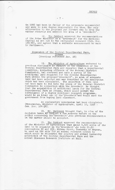
A 1958 Cabinet of Canada document. The Greenbelt Research Farm was an annex to the Experimental Farm on Carling Avenue. During the year 1998 the Greenbelt Farm was transferred from Agriculture Canada to the National Capital Commission for $1 dollar. The property is a National Interest Land Mass and cannot be sold or subdivided. The Experimental Farm on Carling is also a National Interest Land Mass and a National Historic Site of Canada. 

3.)Mer Bleue - "Protect the Greenbelt from devastating development."
CPAWS-Canadian Parks and Wilderness Society, Ottawa Valley Chapter:
"As the population in the National Capital Region continues to grow, the City of Ottawa has identified a need for new transportation infrastructure to support the growing communities south of Orleans. Their preferred option is to extend Brian Coburn Boulevard across the Greenbelt to connect with the existing highway south of the intersection of Highway 174 and Blair Road."

" The proposed high speed, multi-lane highway will have a devastating impact on the ecological integrity of the Greenbelt and should not be built in the area being advanced by the City of Ottawa.The new highway will sever all natural linkages between Mer Bleue, Greens Creek and the Ottawa River, and will adversely impact Mer Bleue Bog-an internationally recognized wetland and the most biodiverse area in eastern Ontario."

"Other options do exist, including expanding the proposed LRT network farther into Orleans, or improving the design of existing infrastructure such as Innes Road, which already crosses the Greenbelt."