A group called Reimagine Ottawa wanted to know why: "The Dow's Lake parking lot will be rezoned as Mixed-Use and not Institutional." "Queen Juliana Park will be left as Mixed Use and not Institutional." (Google: "Questions Reimagine Ottawa.")
------------------------------------------------------------
A Timeline of Experimental Farm land grabs:
1.) 1970's - Agriculture Ministers Eugene Whelan and Bud Olson refuse to give the National Capital Commission 700 acres of the Experimental Farm in Ottawa for housing.
2.) 1988 - 91 acres of the Farm are sold to the City of Ottawa, where Walmart and the Skyline Towers are now located.
3.) 2008 - Agriculture Minister Gerry Ritz refused to give the NCC 50 acres of land directly across the street from the Civic.
5.) 2016 - The NCC rejected the Farm as a location for a new health care facility; they preferred Tunney's Pasture.
6.) 2016- Shortly after that, an announcement was made that 60 acres would be annexed from the Farm so that a mega hospital could be built on the site.
 |
| Queen Juliana Park is located within the blue lines, and encompasses 33.5 acres of land. |
 |
| Another view of Queen Juliana Park with the Sir John Carling Building in the distance. |
f) what are the precise boundaries of the property to be leased to the Ottawa Hospital, known as the Sir John Carling site or site # 11 by the National Capital Commission.
g) what price does the government plan to charge the Ottawa Hospital as rent for the Sir John Carling site, known as site # 11 by the National Capital Commission.
Answers to questions posed by MP Pierre Poilievre:
- The market value of the Dow's Lake parking lot is $4,021,000.
- The number of trees removed will be 750 in addition to the Historic Hedge Collection near the DARA Tennis Club. The South Azimuth is part of the Dominion Observatory National Historic Site of Canada and it will be demolished because Maple Drive is being widened and converted to an emergency vehicle route.
The land mass allocated to the Ottawa Hospital in 2016:
- North Boundary---Carling Avenue between Bayswater and Preston
- East Boundary---from Preston to Prince of Wales Drive
- South Boundary---Prince of Wales Drive (600 metres) to 90 degrees west to Birch Drive
- West Boundary---Birch Drive/Maple Drive up to Winding Lane and back to Carling Avenue at Bayswater (quarter of a circle around the Dominion Observatory (From: A Public Services and Procurement Canada document given to MP Pierre Poilievre.)
The Canadian Minister of Heritage was probably consulted by the Minister of the Environment because:
a.) The Experimental Farm is a National Historic Site of Canada.
b.) The Dominion Observatory Campus will be negatively impacted by the construction of a health care facility. In fact, the hospital does not want "irregularly shaped parcels of land" and is recommending that the Observatory buildings either be removed or demolished. The Astrophysical Observatory and 2 other buildings on the land are Classified. The government wanted to demolish the Observatory and Booth Barn during the mid 1990's.
----------------------------------------------------------------------------------------
Reimagine Ottawa is correct, 12 acres of land that were designated for a new health care facility are being rezoned:
"City files re-zoning application for new Ottawa Civic Campus." CBC News, August 18, 2017:
"The City has filed an application to re-zone five hectares of land on the Central Experimental Farm to be used for the future Civic Campus of the Ottawa Hospital. In a filing on Friday, the City said it wants to amend the Official Plan to re-designate the land from "agricultural research area" to "general urban area" and relinquish the green space from the Farm."
General urban area zoning will facilitate the construction of high rise condominiums on the Dow's Lake parking lot and Queen Juliana Park. In fact, the City of Ottawa's Official Plan encourages intensification near arterial routes, and Carling Avenue is an arterial route. The Preston-Carling District Secondary Plan allows heights of up to 20 storeys.
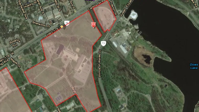 |
| All of the land within the red lines will be taken over by a new hospital, massive parking lots, condominiums and commercial buildings. The people of Canada will lose a $4 million dollar parking lot at Dow's Lake; the 33-acre QJPark; the Dominion Observatory Campus; the Sir John Carling Building Annex or cafeteria; K.W. Neatby Building and the CFIA Laboratory; at least 500 trees (see the letter sent to the NCC by former Ottawa Mayors Jim Durrell and Jacquelin Holzman); and green space. The Civic already needs more land in order to expand, so the William Saunders Building and greenhouses will be sacrificed for this controversial, unwanted project. (Photo from CBC News.) |
No comments:
Post a Comment